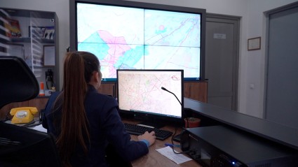
Uzbekistan is introducing a GIS-based innovative system aimed at enhancing the real-time monitoring, forecasting, and emergency response. The new system automates the collection and analysis of data on territorial conditions and emerging hazards and enables scenario modelling through a unified digital mapping and information resources.
High-performance ICT equipment and system’s software, developed in line with the operational needs of the Ministry of Emergency Situations of Uzbekistan, ensure centralized data collection from regional departments, spatial analysis and visualization, operational management, and the forecasting and planning of disaster risk reduction measures. This contributes to faster and more targeted public warning, more efficient use of emergency response resources, and improved interagency coordination.
The GIS-based system has been developed with the support of the United Nations Development Programme (UNDP), in partnership with the Ministry of Emergency Situations and Uzhydromet, with financial support from the Green Climate Fund.
In parallel, a multi-module platform for assessing the risks of snow avalanches, mudflows, and hydrological drought is being developed jointly with Uzhydromet. The platform will complement the functionality of the Ministry of Emergency Situations’ system and strengthen national early warning capacities.
The introduction of the GIS-based system is part of UNDP’s broader efforts to strengthen Uzbekistan’s Multi-hazard early warning system and enhance community resilience to climate change-related natural hazards. By improving risk anticipation, early warning, and emergency preparedness, the system directly contributes to saving lives and strengthening the country’s resilience to disasters.